How to choose a ferry route in Scandinavia and the Baltic
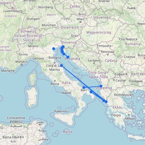
The route map shows many individual connections, but most trips fit into a small number of main corridors. Start with your destination and the amount of driving you are willing to do. A short ferry can keep the journey flexible, while a longer overnight crossing can replace a hotel stay and leave you closer to your final destination.
| Travel corridor |
Main route choices |
Usually best for |
| Germany to Denmark |
Puttgarden-Rødby or Rostock-Gedser |
Driving through Denmark toward Copenhagen, Sweden or Norway |
| Germany to Sweden or Finland |
Routes from Kiel, Rostock and Travemünde |
Reducing driving and traveling directly with a car or camper |
| Denmark to Norway |
Hirtshals to southern and western Norway |
Road trips to Kristiansand, Larvik, Stavanger or Bergen |
| Denmark to Sweden |
Øresund Bridge or Helsingør-Helsingborg ferry |
Flexible travel toward Malmö, Gothenburg or central Sweden |
| Sweden, Finland and the Baltics |
Routes through Stockholm, Turku, Helsinki, Tallinn and the Åland Islands |
City trips, overnight crossings and Baltic road trips |
| Iceland and the Faroe Islands |
Hirtshals-Faroe Islands-Iceland |
Long-distance travel with your own car, motorcycle or camper |
From Germany to Denmark, Sweden, Norway or Finland
Germany offers the widest choice of entry routes into the Nordic ferry network. Puttgarden-Rødby and Rostock-Gedser are short crossings into Denmark and work well when you want to continue driving toward Copenhagen, southern Sweden or the Danish ports for Norway.
For a more direct journey, ferries from Rostock and Travemünde reach southern Sweden, while longer routes connect Kiel with Gothenburg and Oslo and Travemünde with Helsinki. These longer sailings can reduce the distance driven on land, but they require more planning around departure times, vehicle space and cabins.
Denmark to Sweden: ferry or bridge?
There are two main ways to cross the Øresund area. The Øresund Bridge gives you a continuous road connection between Copenhagen and Malmö. The Helsingør-Helsingborg ferry crosses farther north and can be useful when your route follows the Swedish west coast or continues toward Gothenburg.
The ferry is a short break from driving and normally operates frequently throughout the day. The bridge avoids check-in and lets you continue immediately. Compare the complete route rather than only the crossing itself, as the best option depends on where you enter Denmark and where you are heading in Sweden.
FerryGoGo has traveled the Denmark-Sweden loop using Puttgarden-Rødby, Helsingør-Helsingborg and the Øresund Bridge. Our main takeaway was that the ferry and bridge are not direct substitutes for every journey. Their locations and the flexibility of combination tickets can matter as much as the ticket price.
Denmark to Norway
Hirtshals is the main Danish departure point for Norway. Shorter crossings reach Kristiansand and Larvik, while longer services continue toward Stavanger and Bergen. Choose the arrival port around your road trip rather than simply selecting the fastest sailing.
Kristiansand and Larvik are practical for southern and eastern Norway. Stavanger and Bergen place you much closer to the fjords and western Norway, potentially replacing a long drive after arrival. Overnight comfort and cabin availability become more important on the longer routes.
Sweden, Finland and the Åland Islands
The central Baltic network connects Stockholm with Turku and Helsinki, often with calls in the Åland Islands. These are larger passenger and vehicle ferries, and overnight sailings can work as both transportation and accommodation.
The Åland Islands are not just a stop between Sweden and Finland. They are also a destination with several possible arrival ports. Use the map to check whether your sailing stops briefly in Åland or allows you to disembark there.
Ferries to Estonia, Latvia and Lithuania
Helsinki-Tallinn is the main short corridor between Finland and Estonia and is useful for both city trips and longer road journeys. Longer Baltic routes connect Sweden, Finland and Germany with ports in Estonia, Latvia and Lithuania.
These routes can be particularly useful when traveling with a car because they avoid driving around the Baltic Sea. Compare the arrival port carefully: Tallinn, Riga, Liepāja, Ventspils and Klaipėda lead into very different parts of the region.
Iceland and the Faroe Islands
The North Atlantic route from Hirtshals travels via the Faroe Islands to Seyðisfjörður in eastern Iceland. This is a multi-day crossing rather than a normal regional ferry, but it is the main option for reaching Iceland with your own car, camper, motorcycle or 4×4.
Sailings are seasonal and vehicle spaces and preferred cabins can be limited during popular travel periods. The Faroe Islands can be booked as the final destination or as a stopover on the longer journey to Iceland.
Which type of route suits your trip?
- For the shortest crossings: look at Puttgarden-Rødby, Helsingør-Helsingborg and Helsinki-Tallinn.
- For less driving: compare direct routes from Germany to Sweden, Norway or Finland.
- For a night on board: consider the longer Baltic routes and the cruise ferries to Norway, Sweden and Finland.
- For a car or camper: check vehicle dimensions, deck space and cabin availability before booking.
- For foot travel: compare terminal access as well as the ferry itself, since some Nordic ports are easier to reach by public transportation than others.
- For Iceland or the Faroe Islands: plan around the sailing calendar rather than treating the route as a frequent everyday connection.
Routes, operators and seasonal schedules can change. Use the interactive map to identify the most logical corridor, then check the current sailing and booking conditions for your exact travel date.