
Planning a ferry trip is rarely just about finding one crossing.
More often, you start with a rough idea. You want to reach an island, take your car abroad, avoid a long drive, travel overnight, or work out whether a ferry can make the journey calmer rather than simply longer.
That is why we rebuilt FerryGoGo.com around interactive ferry maps, local route pages and practical route context.
The new FerryGoGo.com is built for the planning stage of a trip: when you know roughly where you want to go, but not yet which port, crossing or combination of routes makes the most sense.
This page explains how the new structure works. For the wider story behind FerryGoGo, our team and how we started, you can also read our About FerryGoGo page.
What changed in the new FerryGoGo.com?
The rebuild changed FerryGoGo.com from a more traditional ferry information website into a route-first planning platform. The biggest difference is that maps, regions and local ferry questions now lead the structure of the site.
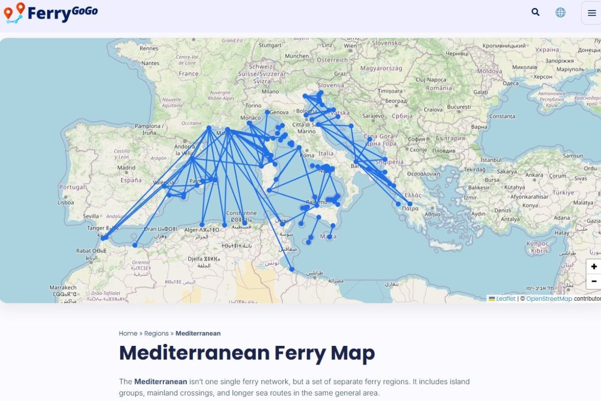
- Maps are now central: most country, region and destination pages start with a visual overview of the available ferry routes.
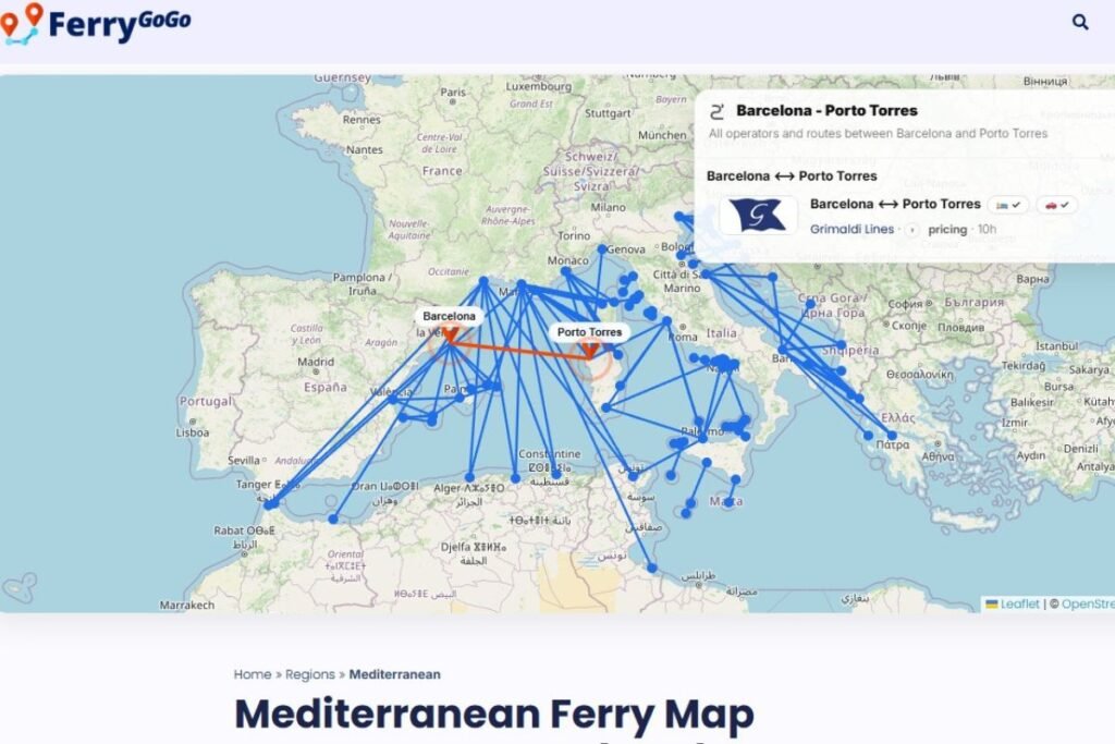
- Routes are easier to compare: crossings can show ports, operators, estimated prices, approximate sailing times and whether a route is usually a day or night ferry.
- Local sections are clearer: travellers can start from country entrances such as Ireland, France, Italy, Spain and the United States.
- The route comes before the booking: the site is designed to help travellers understand their options before choosing where to book.
Why maps make ferry planning easier
Ferry travel becomes much easier to understand when you can actually see the routes.
A list of crossings can tell you that a route exists. A map helps you understand how that crossing fits into the trip. It shows whether a port is close to your destination, whether there is a nearby alternative, and whether the route could be part of a larger journey from A to B, or even from A to B to C.
That is especially useful in ferry-heavy regions such as Ireland, France, Italy, Spain, Scandinavia, Greece, the Caribbean and island destinations around the world. In those places, the best route is not always the most obvious one.
For example, you might use the map to compare ferry routes from Ireland to the UK and mainland Europe, look at ferries from France to the UK or Mediterranean islands, or explore Spanish ferry routes to the Balearic Islands, Canary Islands and beyond.
How to use the FerryGoGo maps
The easiest way to use FerryGoGo.com is to start with a country, region or destination page and let the map give you the first overview.
- Start with a country, region or destination page.
- Use the map to see which ports and routes connect.
- Click a route to compare the operator, approximate duration, estimated price and day/night indication.
- Check nearby alternatives before deciding which crossing fits your trip best.
- Use the route guides and travel tips underneath the map for practical context.
This is useful when you know the destination, but not yet the route. You may want to reach an island, bring your car, avoid a long drive, travel overnight or build a larger road trip around one or more ferry crossings.
More than a route database
We do collect and structure ferry route information, but the aim is not just to show that a ferry exists.
The more useful question is: does this route make sense for your trip?
That is why our country, region and destination pages are built to explain the practical differences between crossings. Depending on the page, you may find:
- a visual overview of the available ferry routes
- the main ports and operators
- an indication of typical prices or starting fares
- whether the crossing is usually a day ferry or night ferry
- whether the route is suitable for cars, campervans or motorbikes
- whether the crossing is a short local ferry, island ferry, passenger ferry or longer international route
- which routes are most useful for a wider holiday itinerary
For many trips, the best ferry is not automatically the shortest one. A slightly longer sailing may land you closer to your first real stop. An overnight ferry with a cabin may replace a hotel night. A smaller local crossing may be the route that makes an island-hopping trip work.
Those are the differences we want FerryGoGo.com to make clearer.
A global ferry website with local entrances
FerryGoGo.com is our international ferry platform, but the new structure is not just about covering more countries. It is about making ferry information useful for the way people in each market actually plan their trips.
Someone planning ferries from Ireland has different questions from someone looking at ferries in Italy, Spain, France or the United States. The same applies to travellers comparing crossings to islands such as Sardinia, Sicily, Corsica, Mallorca, the Greek islands, the Bahamas or destinations in Thailand.
That is why FerryGoGo.com now has local country entrances such as Ireland, France, Italy, Spain and the United States. These sections are designed around local route logic, local destinations and the ferry questions that are most relevant in that market.
Alongside FerryGoGo.com, we also continue to operate local platforms such as FerryGoGo.co.uk, FerryGoGo.nl and FerryGoGo.de for the UK, Dutch and German ferry markets.
Backed by real ferry experience
The maps give the structure, but real travel experience gives the context.
Over the years, we have travelled on many of the ferry routes we write about, from Channel crossings and North Sea night ferries to routes in Scandinavia, the Mediterranean, Australia, Thailand and Malaysia.
That experience helps us judge routes in a more practical way: when a cabin is worth it, when a nearby port is easier, when a longer crossing can save driving time, and why the best ferry is not always the fastest ferry.
We do not need to turn every route page into a travel diary. But first-hand experience does change how we explain ferry travel. It helps us look beyond sailing time alone and focus on the complete travel day: the drive to the port, the boarding process, the time onboard, the arrival port and the journey after the ferry.
That is where FerryGoGo can be most useful: not just showing a route, but helping travellers understand whether that route is actually a good fit.
The route first, the booking after
Our goal is simple: help travellers understand the route before they book.
A ferry crossing is not just a line between two ports. Very often, it decides how relaxed, practical and enjoyable the whole journey becomes.
That is why we rebuilt FerryGoGo.com around maps, routes and real travel experience. Not to make ferry planning more complicated, but to make the options easier to see before you choose.
You can start by browsing our ferry regions, exploring our ferry destinations, or reading more practical advice in our travel information section.
Questions about the FerryGoGo maps
Do the FerryGoGo maps show every ferry route?
Our aim is to map the most useful ferry routes for each country, region and destination. Ferry services can change, so we keep improving and updating the maps as routes, operators and travel patterns change.
Are the prices exact booking prices?
Prices shown on FerryGoGo are usually indications or starting fares. Ferry prices can change based on season, vehicle type, cabin choice, passenger numbers and availability. Always check the final price with the ferry operator or booking partner before booking.
Does FerryGoGo sell ferry tickets?
No. FerryGoGo helps travellers compare routes, understand alternatives and find the most practical ferry option. When relevant, we link to ferry operators or booking partners where tickets can be booked.
Where should I start?
The easiest place to start is with a country, region or destination page. From there, use the map to compare routes and then read the route information underneath for extra context.
For more about who is behind the platform, how FerryGoGo started and how we work, visit our About FerryGoGo page.