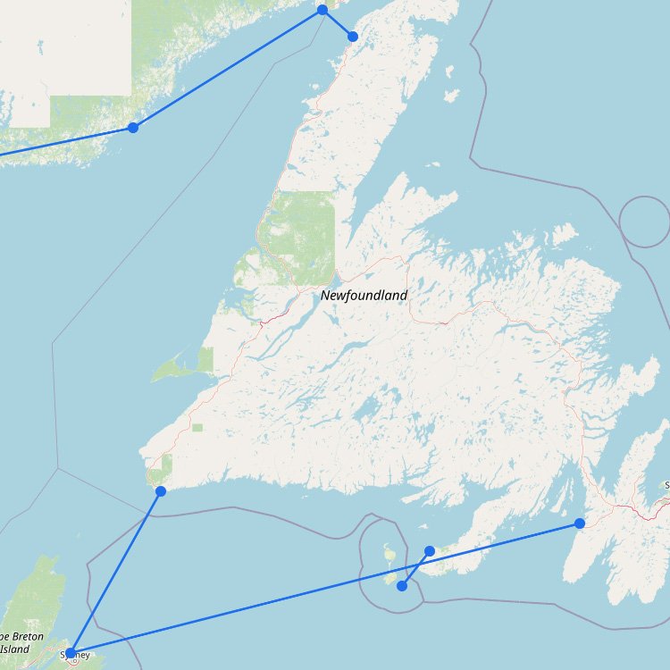
Port aux Basques or Argentia: which Newfoundland ferry should you take?
The shorter ferry is not always the quickest route to your final destination. Port aux Basques and Argentia are on opposite sides of Newfoundland, so your choice can add or remove a substantial amount of driving.
| Route |
Approximate crossing |
Operating period |
Usually best for |
| North Sydney-Port aux Basques |
About 7 hours |
Year-round |
Western Newfoundland, Gros Morne and cross-island road trips |
| North Sydney-Argentia |
About 16 hours |
June to September |
St. John’s, the Avalon Peninsula and eastern Newfoundland |
Choose Port aux Basques for western Newfoundland
Port aux Basques is the main year-round gateway to Newfoundland. The crossing is shorter, generally has more sailing options and places you at the western end of the Trans-Canada Highway.
This is usually the logical route for Gros Morne National Park, Corner Brook, the southwest coast and road trips that continue from west to east across the island. The disadvantage is the long onward drive when St. John’s or the Avalon Peninsula is your main destination.
Choose Argentia for St. John’s and eastern Newfoundland
Argentia is much closer to St. John’s and the Avalon Peninsula. The ferry spends considerably longer at sea, but it can replace a large part of the drive across Newfoundland.
This seasonal route is most useful when your itinerary focuses on eastern Newfoundland or when you want to combine both ferries in one road trip. For example, you can arrive through Argentia, travel west across the island and return from Port aux Basques without retracing the entire route.
Is a cabin worth booking?
A private cabin is particularly valuable on the approximately 16-hour Argentia crossing and on any overnight sailing. It gives you a bed and private bathroom and makes it much easier to begin the next day’s drive rested.
A cabin is less essential on a daytime Port aux Basques crossing, although families and travelers taking an overnight departure may still appreciate one. General seating is available, with paid reserved seating on some vessels. Sleeping in your vehicle, on the floor or on an outside deck is not permitted.
Taking a car, camper or trailer
- Book early: preferred sailings, vehicle spaces and cabins can sell out during busy summer periods.
- Enter the full dimensions: include trailers, bicycle racks, roof boxes and anything extending beyond the vehicle.
- Pack a separate overnight bag: access to the vehicle deck is restricted during the crossing.
- Allow time at the terminal: Marine Atlantic currently requires passengers to complete check-in at least two hours before departure.
- Plan the drive after arrival: avoid judging the routes only by their time at sea.
Weather delays and cancellations
Both routes cross open water and can be affected by strong winds, rough seas or other operational restrictions. Check Marine Atlantic’s travel advisories before driving to the terminal and avoid building an important flight or other fixed connection immediately after your scheduled arrival.
Some flexibility is especially useful around the seasonal Argentia service, which has fewer departures than the year-round Port aux Basques route. If a sailing changes, the alternative port may be on the other side of Newfoundland.
Remember the Newfoundland time difference
Newfoundland is 30 minutes ahead of Nova Scotia. Check the times shown on your reservation carefully when planning terminal transfers and onward travel. Marine Atlantic vessels operate on Newfoundland Time once you are on board.
Ferry between Newfoundland and Labrador
The ferry from St. Barbe to Blanc Sablon is a separate regional connection across the Strait of Belle Isle. It is useful for travel between Newfoundland’s Great Northern Peninsula and Labrador or Québec and is not an alternative to the Marine Atlantic routes from Nova Scotia.
The crossing takes approximately 1 hour and 45 minutes. Ice, weather and seasonal operating conditions can affect the schedule, so check the current service status before traveling to St. Barbe.
Use the interactive map to compare the ports, then choose the route around your full Newfoundland itinerary rather than the shortest ferry crossing alone.