The route map for Hawaii shows why ferry travel here is much more limited than many travelers expect. Even with the island setting, regular ferry service doesn’t link the entire state the way it can in places like Greece or coastal Canada. Instead, ferry routes in Hawaii have usually been local and selective, shaped by distance, sea conditions, and the operating limits between specific islands.
What a Hawaii ferry map doesn’t tell you
Hawaii looks like it was made for ferries, but once you study the map, the story changes. The islands are farther apart than many people expect, sea conditions aren’t always forgiving, and the routes that did exist were never part of one simple island-hopping network.
At first glance, Hawaii seems like it should have ferries linking most places. In practice, it has never worked that way. The map helps explain why: the islands are spread out, some crossings are more exposed than they look, and ferry travel has usually depended on specific routes between specific ports, not a broad statewide system.
Hawaii doesn’t work like the Greek Islands or the Caribbean, where many islands sit inside a wider ferry network.
The distances between islands are tougher than they appear on a map, which helps explain why regular ferry links stayed limited.
Most ferry ideas in Hawaii have been route-based, not system-based. They focused on one crossing or one island pair instead of building a network across the state.
That’s why Hawaii ferry history is harder to summarize than most people expect. There have been attempts, but scaling them up has been difficult, and keeping them running has been even harder.
The ferry connections people remember most
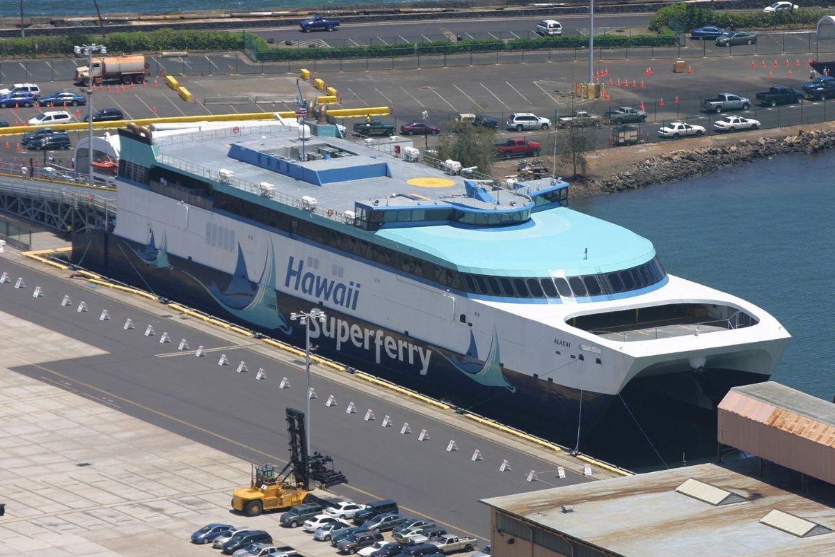
The best-known modern attempt was the Hawaii Superferry, which ran between Oʻahu (Honolulu) and Maui (Kahului) from 2007 to 2009. The service carried both passengers and vehicles and was promoted as a faster alternative to flying for inter-island travel.
The company had been working on the plan for years. It introduced large high-speed catamarans built to carry up to 866 passengers and 282 vehicles. Plans also called for expansion to Kauaʻi and the Big Island, which would have made ferries a bigger part of inter-island travel.
Trouble started quickly. Opposition wasn’t only political. It was local, visible, and intense. Environmental concerns were a major issue, and many residents felt the company moved too fast. Critics argued the service could affect marine life, spread invasive species between islands, and add pressure to local communities. The protests became widely known partly because some of them happened in the harbor, with people on surfboards blocking access.
Service began in 2007, but it was repeatedly disrupted by:
court injunctions
harbor blockades by protesters
political disputes over environmental rules
A special law briefly allowed the company to keep operating while the legal fight continued, but the situation never fully settled. The ferry ran in a climate of uncertainty, which made long-term operations difficult to sustain.
In March 2009, the Hawaii Supreme Court ruled the ferry couldn’t continue without a full environmental impact study. That decision effectively ended the service.
Shortly after:
operations stopped immediately
staff were laid off
the company filed for bankruptcy
The vessels were later sold to the United States Navy for far less than their original build cost.
The main point is simple: Hawaii has had ferry ambitions, but turning them into a stable inter-island system has been much harder than a map makes it seem. Distance, exposure, politics, and local resistance all mattered. So if you look at a Hawaii ferry map today, you’re not seeing a dense, active network. You’re mostly seeing where ferry travel has been possible in theory, but far harder in practice.
Here you can read more about the Hawaii super ferry.
Find ferry routes in other parts of the US
Explore additional crossings with our US ferry route search. Search by destination or narrow the results with more detailed filters.