Getting to Koh Samui from the mainland
Showing all 25 services
Chumphon (Thung Makham Noi) ↔ Ko Samui (Pralan)
Lomprayah · 3h 30m🚗 ✓🚐 ✓From THB 900
Ko Samui (Big Buddha Pier) ↔ Koh Phangan (Haad Rin Queen Pier)
Haad Rin Queen · 1h 30m🚗 ✓🚐 ✓From THB 199
Ko Samui (Big Buddha Pier) ↔ Koh Phangan (Haad Rin Queen Pier)
Haad Rin Queen · 50m🚗 ✓🚐 ✓From THB 199
Ko Samui (Pralan) ↔ Koh Phangan (Thong Sala Pier)
Lomprayah · 20m🚗 ✓🚐 ✓From THB 300
Ko Samui (Pralan) ↔ Koh Phangan (Thong Sala Pier)
Lomprayah · 20m🚗 ✓🚐 ✓From THB 300
Ko Samui (Pralan) ↔ Koh Tao (Mae Haad Pier)
Lomprayah · 1h 30m🚗 ✓🚐 ✓From THB 750
Koh Samui (Bangrak Pier) ↔ Koh Phangan (Thong Sala Pier)
Seatran Discovery · 30m🚗 ✓🚐 ✓From THB 300
Koh Samui (Bangrak Pier) ↔ Koh Phangan (Thong Sala Pier)
Lomprayah · 30m🚗 ✓🚐 ✓From THB 300
Koh Samui (Bangrak Pier) ↔ Koh Phangan (Thong Sala Pier)
Lomprayah · 30m🚗 ✓🚐 ✓From THB 300
Koh Samui (Bangrak Pier) ↔ Koh Phangan (Thong Sala Pier)
Seatran Discovery · 30m🚗 ✓🚐 ✓From THB 300
Koh Samui (Bangrak Pier) ↔ Koh Tao (Mae Haad Pier)
Seatran Discovery · 2h🚗 ✓🚐 ✓From THB 600
Koh Samui (Lipa Noi) ↔ Koh Phangan (Thong Sala Pier)
Raja Ferry · 1h 30m🚗 ✓🚐 ✓From THB 230
Koh Samui (Nathon Pier) ↔ Koh Phangan (Thong Sala Pier)
Lomprayah · 30m🚗 ✓🚐 ✓From THB 300
Koh Samui (Nathon Pier) ↔ Koh Phangan (Thong Sala Pier)
Songserm · 45m🚗 ✓🚐 ✓From THB 250
Koh Samui (Nathon Pier) ↔ Koh Phangan (Thong Sala Pier)
Lomprayah · 30m🚗 ✓🚐 ✓From THB 300
Koh Samui (Nathon Pier) ↔ Koh Tao (Mae Haad Pier)
Lomprayah · 1h 30m🚗 ✓🚐 ✓From THB 750
Koh Tao (Mae Haad Pier) ↔ Ko Samui (Pralan)
Lomprayah · 1h 30m🚗 ✓🚐 ✓From THB 750
Koh Tao (Mae Haad Pier) ↔ Koh Samui (Bangrak Pier)
Seatran Discovery · 2h🚗 ✓🚐 ✓From THB 600
Koh Tao (Mae Haad Pier) ↔ Koh Samui (Nathon Pier)
Songserm · 3h🚗 ✓🚐 ✓From THB 700
Koh Tao (Mae Haad Pier) ↔ Koh Samui (Nathon Pier)
Lomprayah · 1h 30m🚗 ✓🚐 ✓From THB 750
SM
Surat Thani (Bandon Pier) ↔ Koh Samui (Nathon Pier)
Sandee Maneerup · 6hovernight🚗 ✓🚐 ✓From THB 250
Surat Thani (Don Sak Pier) ↔ Koh Samui (Lipa Noi)
Raja Ferry · 1h 30m🚗 ✓🚐 ✓From THB 230
Surat Thani (Don Sak Pier) ↔ Koh Samui (Nathon Pier)
Seatran Discovery · 1h 30m🚗 ✓🚐 ✓From THB 350
Surat Thani (Tapee Pier) ↔ Ko Samui (Pralan)
Lomprayah · 45m🚗 ✓🚐 ✓From THB 650
Surat Thani (Tapee Pier) ↔ Koh Samui (Nathon Pier)
Lomprayah · 45m🚗 ✓🚐 ✓From THB 650

Ferry region
Recently updated
920
views · 30 days
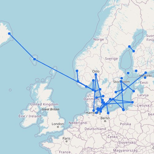
Scandinavia Ferry Map
The interactive ferry map on this page primarily covers ferry routes across Scandinavia and the Baltic States, but…
33
routes
45
ports
16
operators
Explore this ferry region
Destination
Recently updated
360
views · 30 days
Ferries to Kefalonia
The main ferry routes to Kefalonia depart from the mainland port of Kyllini, taking just 90 minutes. Levante…
5
routes
11
connections
3
operators
Explore ferries to this destination
Destination
Recently updated
↗
260
views · 30 days
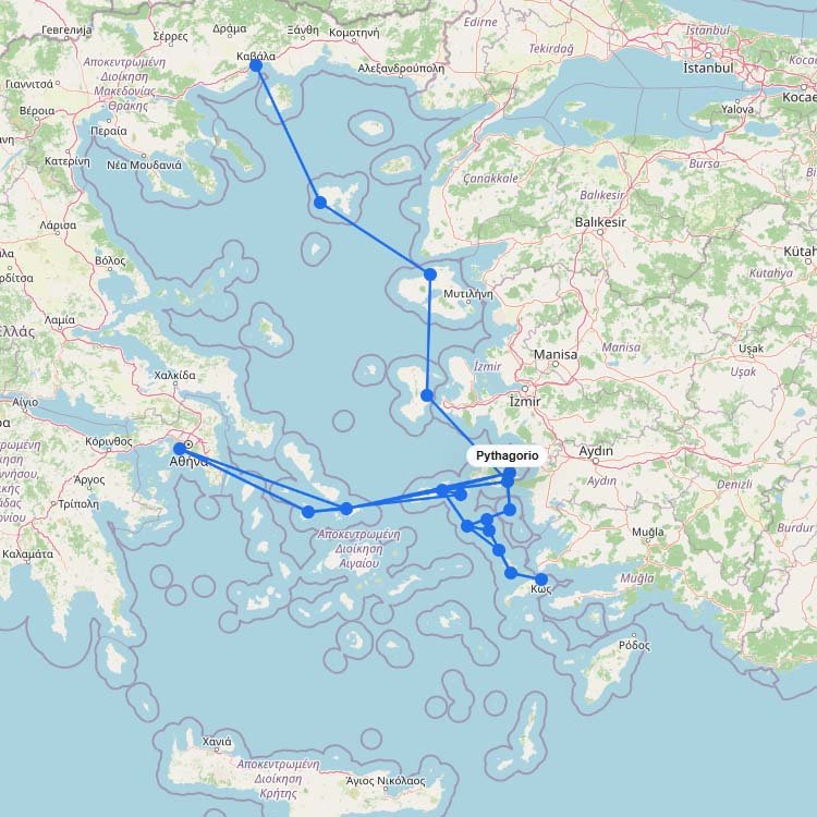
Ferries to Samos
Sitting a mere 1.2 kilometers off the Turkish coast, the twin ports of Vathy and Karlovasi process over…
5
routes
18
connections
4
operators
Explore ferries to this destination
Destination
Recently updated
250
views · 30 days
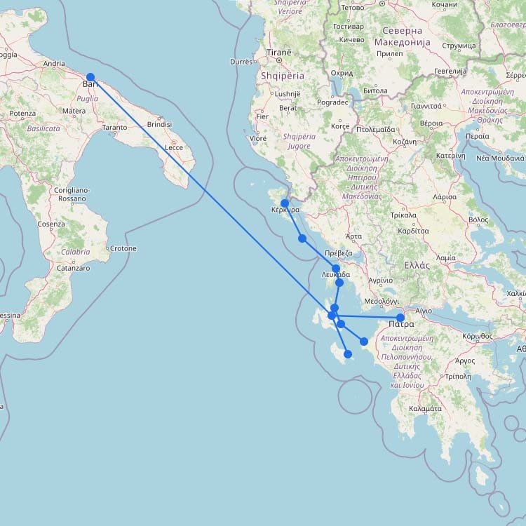
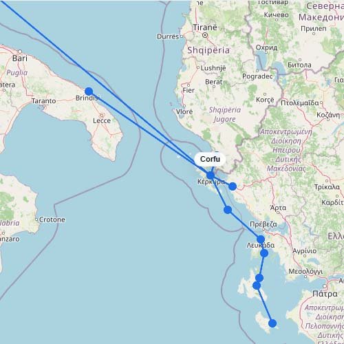
Ferries to Corfu
As shown on the interactive map above, ferry routes to Corfu include a mix of longer international crossings,…
6
routes
12
connections
9
operators
Explore ferries to this destination
Destination
Recently updated
200
views · 30 days
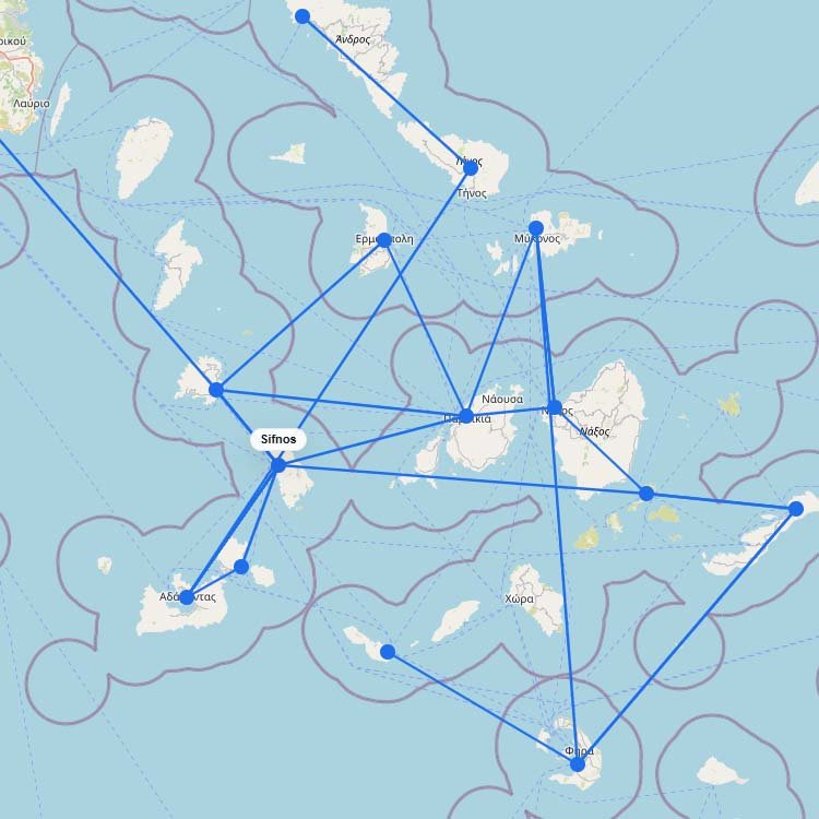
Ferries to Sifnos
Seajets and Aegean Sea Lines are the primary operators serving the western Cyclades, transporting approximately 100,000 passengers annually…
5
routes
15
connections
1
operator
Explore ferries to this destination
Destination
Recently updated
↗
190
views · 30 days
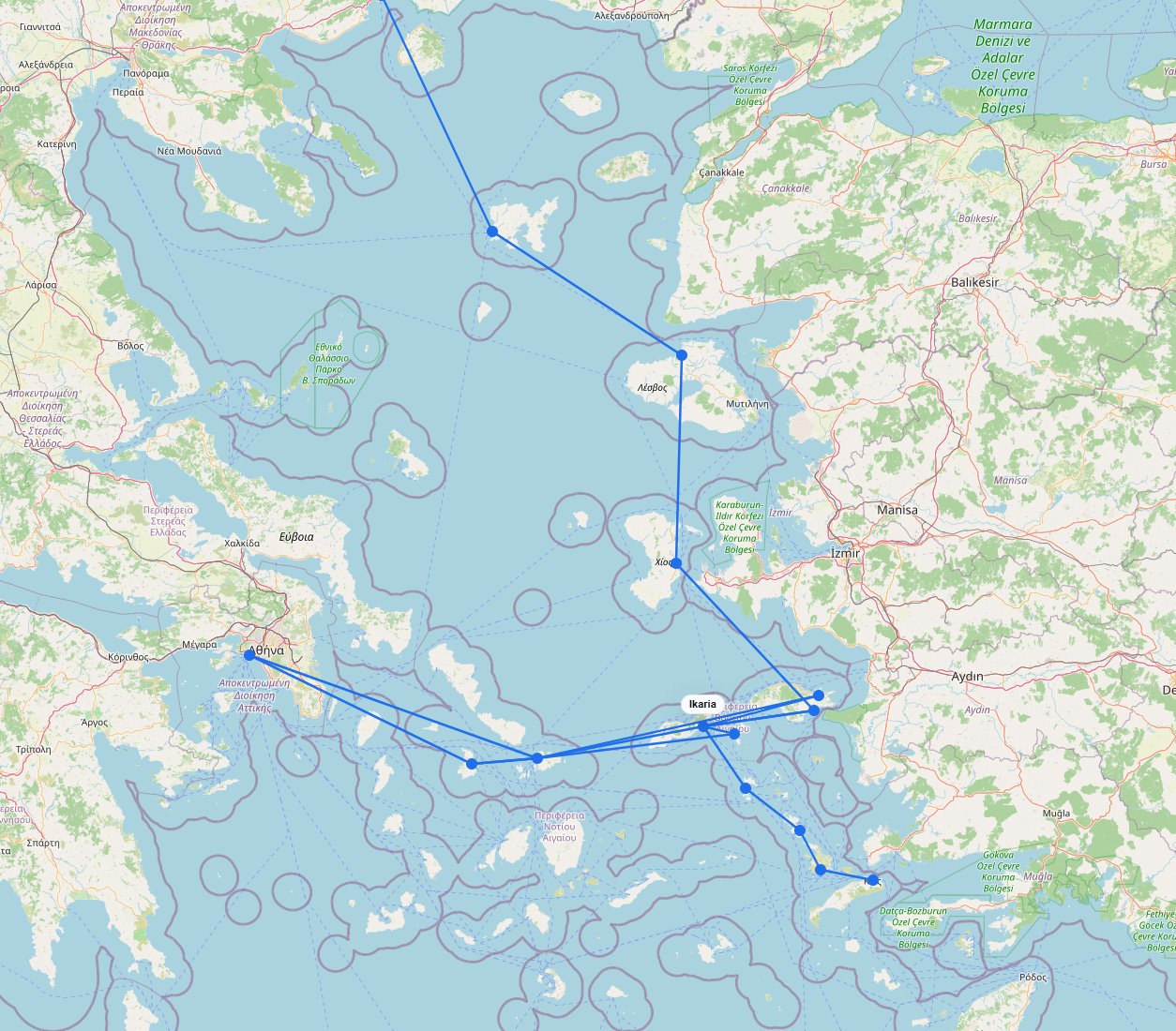
Ferries to Ikaria
Embrace the slow pace of the legendary Blue Zone by boarding a Blue Star Ferries ship out of…
3
routes
15
connections
2
operators
Explore ferries to this destination
No maps match this filter.