Which Nova Scotia ferry fits your trip?
The shortest crossing is not automatically the best route. Look at where the ferry arrives, how much driving it removes and whether the service operates on your travel date. The route map gives you the geographical overview; the comparison below shows the main travel logic.
| Route |
Approximate crossing |
Operating pattern |
Usually best for |
| Bar Harbor-Yarmouth |
3 hours 30 minutes |
Seasonal |
Travel between New England and southwestern Nova Scotia |
| Port aux Basques-North Sydney |
About 7 hours |
Year-round |
Western Newfoundland and most year-round Newfoundland road trips |
| Argentia-North Sydney |
About 16 hours |
Seasonal |
St. John’s, the Avalon Peninsula and reducing the drive across Newfoundland |
| Saint John-Digby |
About 2 hours 15 to 30 minutes |
Year-round |
New Brunswick, the Annapolis Valley and southwestern Nova Scotia |
| Wood Islands-Caribou |
About 75 minutes |
Seasonal |
Prince Edward Island, northern Nova Scotia and Cape Breton road trips |
From Maine to Nova Scotia
The CAT is the direct international ferry between Bar Harbor, Maine, and Yarmouth, Nova Scotia. It carries passengers and vehicles and avoids the long drive through New Brunswick. Yarmouth is particularly useful for exploring southwestern Nova Scotia, including the Acadian Shore and the route toward Digby.
The service is seasonal, so it is not an option for every road trip. Include check-in, border formalities and the onward drive from Yarmouth when comparing the ferry with driving around the Bay of Fundy. Follow the international check-in instructions on your ticket and leave additional time at both terminals.
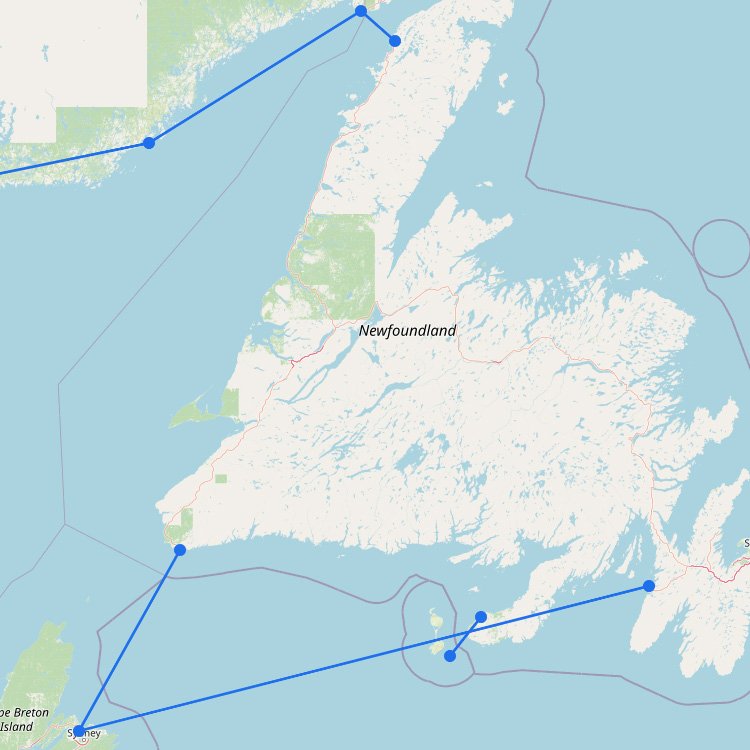
Port aux Basques or Argentia for Newfoundland?
Marine Atlantic operates both Newfoundland routes from North Sydney. Port aux Basques is the shorter and more frequent choice. It operates throughout the year and is generally the logical route for western Newfoundland, Gros Morne National Park and road trips crossing the island.
Argentia is the longer but strategically useful alternative. The seasonal crossing takes considerably longer at sea, but Argentia is much closer to St. John’s and the Avalon Peninsula. For an eastern Newfoundland itinerary, the extra time on the ferry can replace many hours of driving across the island.
Cabins are available on Marine Atlantic vessels and are especially relevant on overnight sailings and the long Argentia route. Vehicle spaces and cabins can sell out during busy periods, so these crossings are worth reserving well ahead of travel. Marine Atlantic currently requires passengers to complete check-in at least two hours before departure.
From New Brunswick to Digby
The Fundy Rose crosses the Bay of Fundy between Saint John and Digby in just over two hours. This route can remove a substantial amount of driving around the bay and is particularly useful for the Annapolis Valley, Digby, Yarmouth and the western side of Nova Scotia.
Compare the sailing time with your complete road journey. The ferry is less useful when your destination lies far to the north or east and the departure time creates a long wait. It becomes much more attractive when Digby is already close to your planned route.
From Prince Edward Island to Nova Scotia
The ferry between Wood Islands and Caribou takes approximately 75 minutes. It is a convenient alternative to driving via the Confederation Bridge and New Brunswick, particularly when traveling between eastern Prince Edward Island, northern Nova Scotia and Cape Breton.
This is a seasonal connection rather than a year-round route. Check the operating period and schedule for your exact travel date before building it into a circular road trip.
Taking a car and booking a cabin
- Reserve vehicle space: book early when traveling in summer, with a camper, trailer or oversized vehicle.
- Enter the correct dimensions: vehicle height and total length can affect availability and price.
- Consider a cabin for Newfoundland: cabins are most valuable on Marine Atlantic’s overnight and longer crossings.
- Do not compare sailing time alone: include check-in, unloading and the drive between the ferry terminal and your final destination.
- Check service updates: Atlantic weather can cause delays or changes, even when the road conditions on land appear good.
Local ferries within Nova Scotia
Nova Scotia also operates several small provincial ferries, including cable ferries at locations such as Englishtown and LaHave. These services function as short links within the provincial road network rather than as alternatives to the main interprovincial routes. Use the map to see whether one falls along your itinerary and check its current status before setting out.
Schedules and operating periods can change. Confirm the current sailing, vehicle requirements and check-in deadline with the operator before traveling to the port.