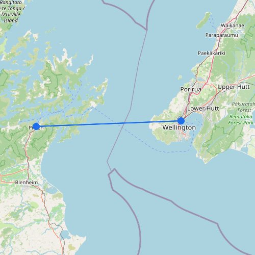
Ferries to Wellington: Route Map
Ferry routes to Wellington cross the notoriously rough Cook Strait, arriving directly into the North Island’s busy capital…
Home » Destinations » Diamond Harbour
A ferry ride to Diamond Harbour takes just eight minutes across the water, which is a nice way to skip the road traffic around Lyttelton. Black Cat Cruises is the largest operator here, moving over 100,000 riders across this scenic bay near Christchurch each year. You can hop off the boat and start walking the beautiful coastal trails right away. Since this boat is only for people and bikes, leaving your car parked at the Lyttelton terminal is the way to go.
Showing all 2 services

Diamond Harbour is not one of those ferry destinations where you need a long sea passage or a full boarding strategy. The crossing is short, but the logistics still matter because this is a working harbour link between Lyttelton and the southern side of Lyttelton Harbour. The ferry is part of the public transport system, connects with Christchurch bus services, and remains the fastest practical water route into Diamond Harbour if you are approaching from the port side rather than driving around the bays.
| Jetty / Access Point | Harbour Context | Logistics Score |
|---|---|---|
| Lyttelton Jetty (Port side departure) |
The Main Boarding Point: This is the urban side of the crossing and the practical ferry link if you are coming from Christchurch by bus or car. | High Utility: The ferry timetable is coordinated with Route 8, making this the cleanest transfer point for people coming from central Christchurch or the airport side. |
| Diamond Harbour Jetty (Banks Peninsula side) |
The Village Landing: This is the direct arrival point for Diamond Harbour itself, avoiding the longer road detour around the harbour. | Fast Access: The water crossing is short, and for many local trips it beats the roughly 30 minute drive around the bays from Lyttelton. |
| Road route via the bays (No ferry boarding) |
The Long Way Around: You can reach Diamond Harbour by road from Christchurch or from Lyttelton via the harbour edge roads. | Useful Backup: This matters if weather, late evening timing, or your vehicle plans make the ferry less practical, but it is not the direct harbour crossing route. |
“Diamond Harbour works best when you think of it as a harbour-side settlement linked to Christchurch by a chain of transport moves: city bus to Lyttelton, short ferry across the water, then straight into the village. The crossing is small, but getting the sequence right makes the place feel much closer to Christchurch than the road map suggests.”
Using this ferry data helps you treat Lyttelton Jetty as the real launch point for Diamond Harbour rather than overcomplicating the trip with a full road loop. Check specialized maps to see how the ferry landing sits relative to Lyttelton, the village foreshore, and the bays on the southern side of the harbour.
Ferry routes to Wellington cross the notoriously rough Cook Strait, arriving directly into the North Island’s busy capital…
Taking a ferry to D’Urville Island involves a special 15-minute barge ride across the strong currents of French…
A ferry ride to Diamond Harbour takes just eight minutes across the water, which is a nice way…
No maps match this filter.